
Preble County: Center Your Business Here!
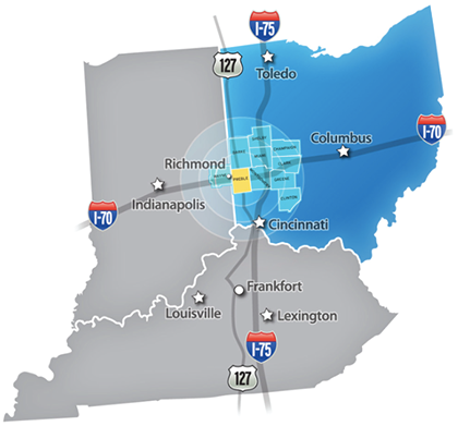 Preble County is centered for success! Located just 40 minutes from Dayton, it is centrally located in the prosperity triangle formed by Cincinnati, Columbus, and Indianapolis. Just 90 minutes from each of these strategic metros, Preble County is square in the nation’s industrial, distribution, and transportation heartland.
Preble County Location Fast Facts
- Dayton-Cincinnati region is the 15th largest market in the U.S.
- Dayton is a top "90-minute" U.S. air market: 90 minutes to 55% of the population and 56% of the income
- Convenient access to 2 top-100 airports
- Immediate access to a population of more than 3 million
- Within a day’s drive of 60% of the U.S. and Canadian markets
Our location offers impressive demographics attractive to manufacturing, agricultural investment, retailers, and small businesses. Check out the industries finding location and logistics success in Preble County!

By Land
Preble County is situated near the Crossroads of America.
- East & West: Highway 70, US Route 35 and 40 (National Road); State Routes 122 and 725
- North & South: US Route 127 and State Routes 121, 177, 503, 726, and 732

By Rail
Preble County has easy access to Ohio’s robust freight rail services provided by Norfolk Southern (NS) on over 2,000 miles of track. Additionally, NS tracks connect with 29 shortline railroads in Ohio.

By Air
Preble County is part of the Dayton-Cincinnati metro area, one of only four metropolitans with access to two top-100 airports: Dayton International and Cincinnati/Northern Kentucky International.